Polish-Soviet border in East Prussia
I think many residents of the Kaliningrad region, as well as many Poles, have often asked themselves the question: why is the border between Poland and the Kaliningrad region exactly this way and not another? In this article, we will try to understand how the border between Poland and the Soviet Union was formed on the territory of the former East Prussia.
Those who are at least a little knowledgeable about history know and remember that before the start of the First World War, the Russian and German empires had a common border, and part of it ran approximately the same way as the current border of the Russian Federation with the Republic of Lithuania.
Then, as a result of the events associated with the Bolsheviks coming to power in 1917 and the separate peace with Germany in 1918, the Russian Empire fell apart, its borders changed significantly, and individual territories that had once been part of it received their own statehood. This is exactly what happened, in particular, with Poland, which regained its independence in 1918. In the same year, 1918, the Lithuanians also founded their own state.
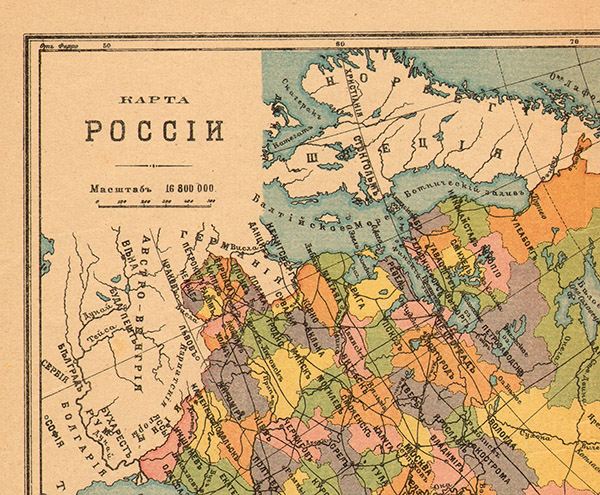
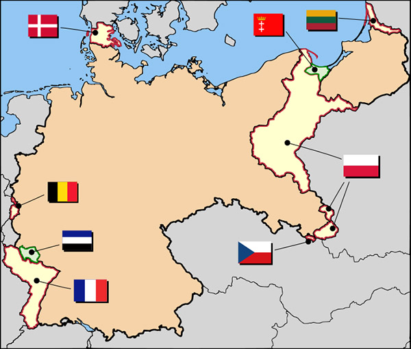
The results of the First World War, including Germany's territorial losses, were consolidated by the Treaty of Versailles in 1919. In particular, significant territorial changes took place in Pomerania and West Prussia (the formation of the so-called "Polish Corridor" and Danzig and its environs receiving the status of a "free city"), as well as in East Prussia (the transfer of the Memel Territory (Memelland) under the control of the League of Nations).
The next (very minor) changes in the borders in the southern part of East Prussia were connected with the results of a plebiscite held in Warmia and Masuria in July 1921. At its end, the population of most of the territories that Poland, counting on the fact that there was a significant number of ethnic Poles living there, would not have been averse to annexing, voted against joining the young Polish Republic. In 1923, the borders in the East Prussian region changed once again: in the Memel Territory, the Lithuanian Riflemen's Union raised an armed uprising, the result of which was the incorporation of Memelland into Lithuania as an autonomous region and the renaming of Memel to Klaipeda. Fifteen years later, at the end of 1938, elections to the city council were held in Klaipeda, according to the results of which the pro-German parties (who ran on a single list) won with an overwhelming majority. After Lithuania was forced to accept Germany's ultimatum on March 22, 1939, to return Memelland to the Third Reich, Hitler arrived in Klaipeda-Memel on the cruiser Deutschland on March 23, where he then addressed the locals from the balcony of the local theater and reviewed the parade of Wehrmacht units. This formalized Germany's last peaceful territorial acquisition before the outbreak of World War II.
The re-division of borders in 1939 did not end with the annexation of the Memel Region to Germany. On September 1, the Wehrmacht's Polish campaign began (this date is also considered by many historians to be the start of World War II), and two and a half weeks later, on September 17, units of the Red Army entered Polish territory. By the end of September 1939, a Polish government in exile was formed, and Poland, as an independent territorial entity, ceased to exist again.
The borders in East Prussia again underwent significant changes. Germany, in the person of the Third Reich, having occupied a significant part of the territory of the Second Polish Republic, again received a common border with the successor of the Russian Empire, the Soviet Union.
The next, but not the last, change of borders in the region under consideration took place after the end of World War II. It was based on decisions taken by the Allied leaders in 1943 in Tehran, and then at the Yalta Conference in 1945. In accordance with these decisions, first of all, the future borders of Poland in the east, common with the USSR, were determined. Later, the Potsdam Agreement of 1945 finally determined that defeated Germany would lose all of the territory of East Prussia, part of which (approximately a third) would become Soviet, and the majority would become part of Poland.
By the Decree of the Presidium of the Supreme Soviet of the USSR of April 7, 1946, the Koenigsberg Region was formed on the territory of the Koenigsberg Special Military District, created after the victory over Germany, and became part of the RSFSR. Just three months later, by the Decree of the Presidium of the Supreme Soviet of the USSR of July 4, 1946, Koenigsberg was renamed Kaliningrad, and the Koenigsberg Region was renamed Kaliningrad.
Below we offer the reader a translation of an article (with minor abbreviations) by Wieslaw Kaliszuk, author and owner of the website “History of the Elbląg Upland” ( Historija Wysoczyzny Elbląskiej ), about the process of forming the borders between Poland and the USSR on the territory of the former East Prussia.
The Polish-Soviet border in former East Prussia
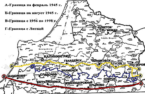
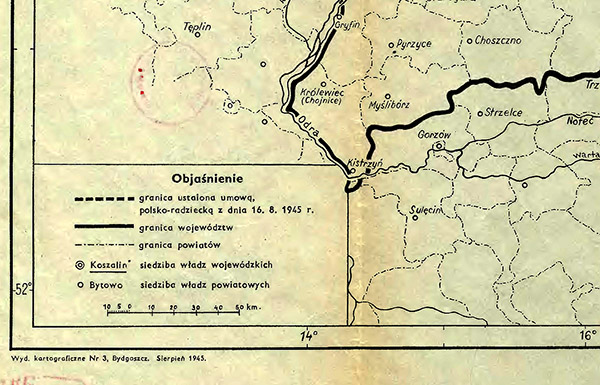
The current Polish-Russian border begins near the town of Wiżajny in the Suwałki region at the junction of three borders (Poland, Lithuania and Russia) and ends in the west, at Nowa Karczma on the Vistula (Baltic) Spit. The border was established by the Polish-Soviet agreement signed in Moscow on 16 August 1945 by the Chairman of the Provisional Government of National Unity of the Polish Republic Edward Osóbka-Morawski and the Minister of Foreign Affairs of the USSR Vyacheslav Molotov. The length of this section of the border is 210 km, which is approximately 5.8% of the total length of Poland's borders.
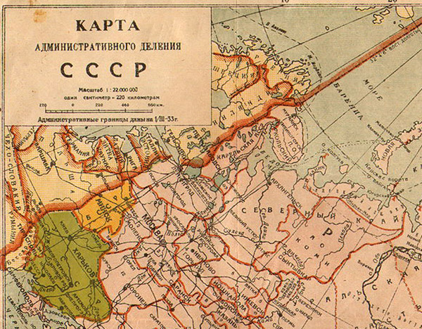
The decision on the post-war border of Poland was made by the Allies already in 1943 at the conference in Tehran (28.11.1943 – 01.12.1943). It was confirmed in 1945 by the Potsdam Agreement (17.07.1945 – 02.08.1945). In accordance with them, East Prussia was to be divided into the southern Polish part (Warmia and Masuria), and the northern Soviet part (approximately a third of the former territory of East Prussia), which received the name "Königsberg Special Military District" (KOVO) from June 10, 1945. From 09.07.1945 to 04.02.1946, the leadership of the KOVO was entrusted to Colonel General K.N. Galitsky. Before this, the Military Council of the 3rd Belorussian Front had been in charge of this part of East Prussia captured by Soviet troops. The military commandant of this territory, Major General M.A. Pronin, appointed to this position on 13.06.1945, had already transferred all administrative, economic and military powers to General Galitsky on 09.07.1945. Major General B.P. Trofimov, who had held the post of Chief of the UMVD of the Königsberg/Kaliningrad Region from 24.05.1946 to 05.07.1947, was appointed the NKVD-NKGB USSR representative for East Prussia.
At the end of 1945, the Soviet part of East Prussia was divided into 15 administrative districts. Formally, the Königsberg Oblast was formed on April 7, 1946 as part of the RSFSR, and on July 4, 1946, with the renaming of Königsberg to Kaliningrad, the oblast was also renamed Kaliningrad. On September 7, 1946, a decree of the Presidium of the Supreme Soviet of the USSR on the administrative-territorial structure of the Kaliningrad Oblast was issued.
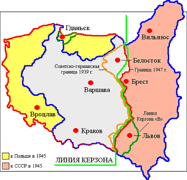
The decision to move the eastern border to the west (approximately to the Curzon Line) and the "territorial compensation" (Poland was losing 175,667 square kilometers of its territory in the east as of September 1, 1939) was made without the participation of the Poles by the leaders of the "Big Three" - Churchill, Roosevelt and Stalin during the conference in Tehran held from November 28 to December 1, 1943. Churchill was supposed to convey to the Polish government in exile all the "advantages" of this decision. During the Potsdam Conference (July 17 - August 2, 1945), Joseph Stalin made a proposal to establish Poland's western border along the Oder-Neisse line. Poland's "friend" Winston Churchill refused to recognize Poland's new western borders, believing that "under Soviet rule" it would become too strong due to the weakening of Germany, while not objecting to Poland's loss of eastern territories.
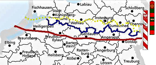
Even before the conquest of East Prussia, the Moscow authorities (read "Stalin") had defined the political borders in this region. As early as July 27, 1944, the future Polish border was discussed at a secret meeting with the Polish Committee of National Liberation (PKNL). The first draft of the borders on the territory of East Prussia was presented to the PKNL by the USSR State Defense Committee (GKO USSR) on February 20, 1945. In Tehran, Stalin drew the contours of the future borders on the territory of East Prussia for his allies. The border with Poland was to run from west to east immediately south of Königsberg along the Pregel and Pissa rivers (approximately 30 km north of the current border of Poland). The draft was much more advantageous for Poland. It would have received the entire territory of the Vistula (Baltic) Spit and the cities of Heiligenbeil (now Mamonovo), Ludwigsort (now Ladushkin), Preußisch Eylau (now Bagrationovsk), Friedland (now Pravdinsk), Darkehmen (after 1938 - Angerapp, now Ozersk), Gerdauen (now Zheleznodorozhny), Nordenburg (now Krylovo). However, all cities, regardless of which bank of the Pregel or Pissa they were on, would then be included in the USSR. Despite the fact that Königsberg was supposed to go to the USSR, its location near the future border would not have prevented Poland from using the outlet from the Frisches Half (now the Vistula/Kaliningrad Lagoon) into the Baltic Sea jointly with the USSR. Stalin wrote to Churchill in a letter dated 4 February 1944 that the Soviet Union was planning to annex the north-eastern part of East Prussia, including Königsberg, since the USSR wanted to obtain an ice-free port on the Baltic Sea. Stalin mentioned this more than once that year in his communications with Churchill and with British Foreign Secretary Anthony Eden, as well as during a Moscow meeting (12 October 1944) with the Prime Minister of the Polish government in exile Stanisław Mikołajczyk. The same issue was raised during meetings (from September 28 to October 3, 1944) with a delegation from the Home Council of the People (KRN, Krajowa Rada Narodowa - a political organization created during World War II from various Polish parties and which was planned to be subsequently transformed into a parliament. - admin ) and the PCNO, organizations in opposition to the Polish government in exile in London. The Polish government in exile reacted negatively to Stalin's claims, pointing out the possible negative consequences of including Königsberg in the USSR. [1] On November 22, 1944, at a meeting in London of the Coordinating Committee, consisting of representatives of the four parties that were part of the government in exile, a decision was made not to accept the dictate of the Allies, including the recognition of the borders along the Curzon Line.
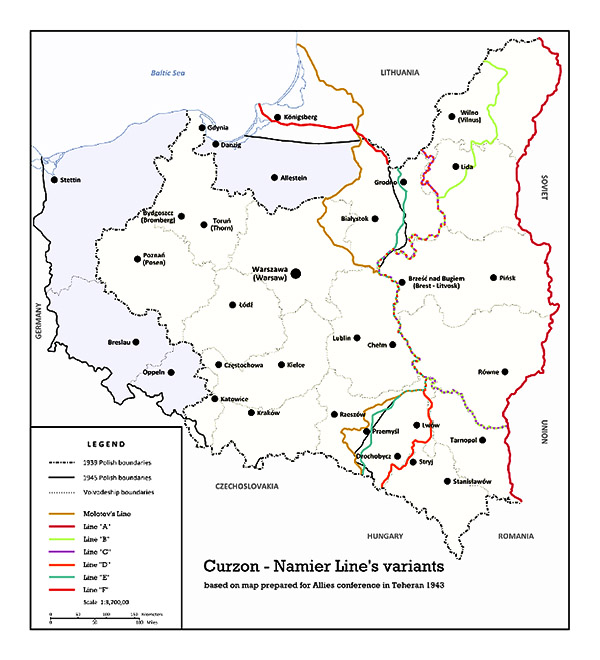
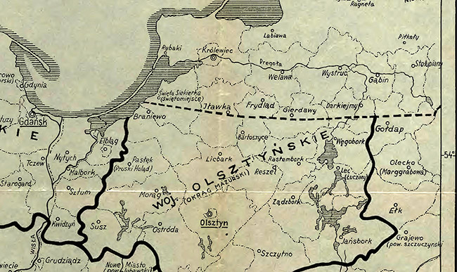
The draft borders proposed in February 1945 were known only to the State Defense Committee of the USSR and the Provisional Government of the Polish Republic (GPPR), which had been transformed from the PKNO, which had ceased to function on 31 December 1944. At the Potsdam Conference it was decided that East Prussia would be divided between Poland and the Soviet Union, but the final demarcation of the border was postponed until the next conference, in peacetime. Only a general outline of the future border was agreed upon, which was to begin at the junction of Poland, the Lithuanian SSR and East Prussia, and run 4 km north of Goldap, 7 km north of Brausberg (now Braniewo) and end at the Vistula (Baltic) Spit about 3 km north of the present-day village of Nowa Karczma. The position of the future border on the same terms was also discussed at a meeting in Moscow on August 16, 1945. There were no other agreements on the passage of the future border in the way it is currently drawn.
By the way, Poland has a historical right to the entire territory of the former East Prussia. Royal Prussia and Warmia went to Prussia as a result of the First Partition of Poland (1772), and the Polish crown lost its feudal rights to the Duchy of Prussia under the Wehlau-Bydgoszcz treaties (and the political shortsightedness of King Jan Casimir), agreed upon in Wehlau on September 19, 1657, and ratified in Bydgoszcz on November 5-6. According to them, Elector Friedrich Wilhelm I (1620-1688) and all his descendants in the male line received sovereignty from Poland. In the event that the male line of the Brandenburg Hohenzollerns was interrupted, the Duchy was again to go under the Polish Crown.
The Soviet Union, supporting Poland's interests in the west (east of the Oder-Neisse line), was creating a new Polish satellite state. It should be noted that Stalin acted, first and foremost, in his own interests. The desire to push the borders of Poland under his control as far west as possible was the result of a simple calculation: Poland's western border would simultaneously be the border of the USSR's sphere of influence, at least until Germany's fate became clear. However, the violations of the agreements on the future border between Poland and the USSR were a consequence of the subordinate position of the Polish People's Republic.
The agreement on the Polish-Soviet state border was signed in Moscow on August 16, 1945. The change in preliminary agreements on the border on the territory of the former East Prussia in favor of the USSR and the consent of Great Britain and the USA to these actions undoubtedly indicate their unwillingness to strengthen the territory of Poland, which was doomed to Sovietization.
After the adjustment, the border between Poland and the USSR was supposed to run along the northern borders of the former administrative districts of East Prussia (Kreis. — admin ) Heiligenbeil, Preußisch Eylau, Bartenstein (now Bartoszyce), Gerdauen, Darkemen and Goldap, approximately 20 km north of the current border. But already in September-October 1945, the situation changed dramatically. In some areas, the border was moved arbitrarily by decision of the commanders of individual units of the Soviet Army. Allegedly, Stalin himself controlled the passage of the border in this region. For the Polish side, the eviction of the local Polish administration and population from already populated and taken under Polish control cities and villages came as a complete surprise. Since many settlements were already populated by Polish settlers, it got to the point that a Pole, leaving for work in the morning, could find out upon his return that his house was already on the territory of the USSR.
Władysław Gomułka, then the Polish Minister for the Recovered Lands (Recovered Lands (Ziemie Odzyskane) is a general name for territories that belonged to the Third Reich until 1939 and were transferred to Poland after the end of World War II by decisions of the Yalta and Potsdam Conferences, as well as by the results of bilateral agreements between Poland and the USSR. — admin ), noted:
"In the first days of September (1945), facts of unauthorized violation of the northern border of the Masurian District by Soviet army authorities were recorded in the territories of the Gerdauen, Bartenstein and Darkemen districts. The border line determined at that time was pushed back into Polish territory by a distance of 12-14 km."
A striking example of a unilateral and unauthorized change of the border (12-14 km south of the agreed line) by the Soviet military authorities is the Gerdauen region, where the border was changed after the demarcation act signed by the two sides on July 15, 1945. The Commissioner for the Masurian District (Colonel Jakub Prawin, 1901-1957 - member of the Communist Party of Poland, brigadier general of the Polish Army, statesman; was the plenipotentiary representative of the Polish government at the headquarters of the 3rd Belorussian Front, then the representative of the government in the Warmia-Masuria District, the head of the administration of this district, and from May 23 to November 1945 the first voivode of the Olsztyn Voivodeship. - admin ) was informed in writing on September 4 that the Soviet authorities had ordered the Gerdauen starosta Jan Kaszynski to immediately leave the local administration and resettle the Polish civilian population. The following day (5 September), representatives of J. Prawin (Zygmunt Walewicz, Tadeusz Smolik and Tadeusz Lewandowski) expressed a verbal protest against such orders to representatives of the Soviet military administration in Gerdauen, Lieutenant Colonel Shadrin and Captain Zakroev. In response, they were told that the Polish side would be notified in advance of any changes to the border. In this area, the Soviet military leadership began to evict the German civilian population, while prohibiting access to these territories for Polish settlers. In connection with this, on 11 September, a protest was sent from Nordenburg to the District Prosecutor's Office in Olsztyn (Allenstein). This shows that this territory was still Polish in September 1945.
A similar situation was in the Bartenstein (Bartoszyce) district, whose mayor received all the acceptance documents on July 7, 1945, and already on September 14, the Soviet military authorities gave the order to free the territories around the villages of Schönbruch and Klingenberg from the Polish population [ 2] . Despite protests from the Polish side (September 16, 1945), both territories went to the USSR.
In the Preußisch-Eylau area, the military commandant Major Malakhov transferred all powers to the mayor Petr Gagatko on June 27, 1945, but already on October 16, the head of the Soviet border troops in this area, Colonel Golovkin, informed the mayor about the border being moved one kilometer south of Preußisch-Eylau. Despite protests from the Poles (17.10.1945), the border was moved. On December 12, 1945, on the instructions of Prawin's deputy Jerzy Burski, the mayor of Preußisch-Eylau vacated the city administration and handed it over to the Soviet authorities.
In connection with the unauthorized actions of the Soviet side to move the border, Jakub Prawin repeatedly (September 13, October 7, 17, 30, November 6, 1945) appealed to the central authorities in Warsaw with a request to influence the leadership of the Northern Group of Forces of the Soviet Army. A protest was also sent to the representative of the Northern Group of Forces in the Masurian District, Major Yolkin. But all of Prawin's appeals had no effect.
The result of arbitrary adjustments of the border to the detriment of the Polish side in the northern part of the Masurian District was that the borders of almost all northern counties (powiat - district. - admin ) were changed.
Bronislaw Saluda, a researcher of this problem from Olsztyn, noted:
"...subsequent adjustments to the border line could lead to the fact that some of the villages already occupied by the population could end up on Soviet territory and the work of the settlers to develop it would be wasted. In addition, it happened that the border separated a residential building from the outbuildings or land plot assigned to it. In Shchurkovo, it happened that the border passed through a barn for cattle. The Soviet military administration responded to complaints from the population that the loss of land here would be compensated by land on the Polish-German border."
The Soviet Union blocked the exit to the Baltic Sea from the Vistula Lagoon, and the final demarcation of the border on the Vistula (Baltic) Spit was carried out only in 1958.
According to some historians, in exchange for the consent of the Allied leaders (Roosevelt and Churchill) to include the northern part of East Prussia with Königsberg into the Soviet Union, Stalin proposed transferring Bialystok, Podlasie, Chelm and Przemysl to Poland.
In April 1946, the official demarcation of the Polish-Soviet border on the territory of the former East Prussia took place. But it did not put an end to the change of the border in this region. Until February 15, 1956, 16 more border adjustments took place in favor of the Kaliningrad region. From the initial draft of the border, presented in Moscow by the USSR State Defense Committee for consideration by the PKNO, in reality the borders were moved 30 km to the south. Even in 1956, when the influence of Stalinism on Poland weakened, the Soviet side "threatened" the Poles with "adjustments" of the borders.
On April 29, 1956, the USSR proposed to the Polish People's Republic (PPR) to resolve the issue of the temporary state of the border within the Kaliningrad region, which had been in place since 1945. The border treaty was concluded in Moscow on March 5, 1957. The PPR ratified this treaty on April 18, 1957, and on May 4 of the same year, the exchange of ratified documents took place. After several more minor adjustments, in 1958 the border was defined on the ground and with the installation of border posts.
The Vistula (Kaliningrad) Lagoon (838 sq. km) was divided between Poland (328 sq. km) and the Soviet Union. Poland, contrary to the original plans, was cut off from the exit from the Lagoon to the Baltic Sea, which led to the disruption of the once established shipping routes: the Polish part of the Vistula Lagoon became a "dead sea". The "naval blockade" of Elbląg, Tolkmicko, Frombork and Braniewo also affected the development of these cities. Despite the fact that an additional protocol was attached to the agreement of July 27, 1944, which stated that peaceful ships would be allowed free access through the Pilau Strait to the Baltic Sea.
The final border passed through railways and roads, canals, settlements and even subsidiary farms. The unified geographical, political and economic territory that had been forming for centuries was arbitrarily dismembered. The border passed through the territory of six former krais.
It is believed that as a result of numerous border adjustments, Poland lost about 1,125 square kilometers of territory in this region compared to the original border project. The border drawn "by a ruler" led to numerous negative consequences. For example, between Braniewo and Gołdap, 10 of the 13 roads that once existed were cut by the border, and 30 of 32 roads between Sępopol and Kaliningrad were damaged. The unfinished Masurian Canal was almost cut in half. Numerous power lines and telephone lines were also cut. All this could not help but lead to a worsening of the economic situation in the settlements adjacent to the border: who would want to live in a settlement whose affiliation was not determined? There was a fear that the Soviet side could once again move the border to the south. Any more or less serious settlement of these places by settlers began only in the summer of 1947, during the forced resettlement of thousands of Ukrainians to these regions during Operation Vistula.
The border, which was practically drawn from west to east along the latitude, led to the fact that the economic situation in the entire area from Goldap to Elbląg never improved, although Elbing, which went to Poland, was once the largest and most economically developed city (after Königsberg) in East Prussia. Olsztyn became the new capital of the region, although until the end of the 1960s it was less populated and less economically developed than Elbląg. The negative role of the final division of East Prussia also affected the indigenous population of this region - the Masurs. All this significantly delayed the economic development of this entire region.
The option of drawing the border using a ruler (rare for Europe) was later often used for African countries gaining independence.
The current length of the border between Poland and the Kaliningrad region (since 1991 the border with the Russian Federation) is 232.4 km. This includes 9.5 km of water border and 835 m of land border on the Vistula Spit.
Two voivodeships share a border with the Kaliningrad region: Pomeranian and Warmian-Masurian, and six counties: Nowodworski (on the Vistula Spit), Braniewski, Bartoszycki, Kęszynski, Węgorzewski and Gołdapski.
There are border crossings on the border: 6 land (road crossings Gronowo - Mamonovo, Grzechotki - Mamonovo II, Bezledy - Bagrationovsk, Gołdap - Gusev; railway crossings Braniewo - Mamonovo, Skandava - Zheleznodorozhny) and 2 sea crossings.
On July 17, 1985, an agreement was signed in Moscow between Poland and the Soviet Union on the delimitation of territorial waters, economic zones, marine fisheries zones and the continental shelf of the Baltic Sea.
The western border of Poland was recognized by the German Democratic Republic by the treaty of July 6, 1950, and by the Federal Republic of Germany by the treaty of December 7, 1970 (paragraph 3 of Article I of this treaty states that the parties have no territorial claims against each other and renounce any claims in the future. However, before the unification of Germany and the signing of the Polish-German border treaty on November 14, 1990, the FRG officially declared that the German lands that were ceded to Poland after World War II were in the "temporary possession of the Polish administration."
The Russian enclave on the territory of former East Prussia, the Kaliningrad Region, still has no international legal status. After World War II, the victorious powers agreed to transfer Königsberg to the jurisdiction of the Soviet Union, but only until an agreement was signed in accordance with international law, which would ultimately determine the status of this territory. An international treaty with Germany was signed only in 1990. The Cold War and Germany, divided into two states, prevented it from being signed earlier. And although Germany officially renounced its claims to the Kaliningrad Region, Russia has not formally established sovereignty over this territory.
[1] As early as November 1939, the Polish government in exile was considering the question of incorporating all of East Prussia into Poland after the end of the war. Also in November 1943, the Polish ambassador Edward Raczynski, in a memorandum sent to the British authorities, mentioned, among other things, the desire to incorporate all of East Prussia into Poland.
[2] Schönbruch (now Szczurkowo/Shchurkovo) is a Polish settlement located right on the border with the Kaliningrad Oblast. During the formation of the border, part of Schönbruch ended up on Soviet territory, and part on Polish territory. The settlement was marked on Soviet maps as Shirokoe (it no longer exists). It was not possible to find out whether Shirokoe was inhabited.
Klingenberg (now Ostre Bardo) is a Polish settlement a few kilometers east of Shchurkovo. It is located right on the border with the Kaliningrad region.